Unmanned & Automated SystemsSC100
Entry Level UAV LiDAR Scanning System
Color Point Cloud with Highly Integrated Camera
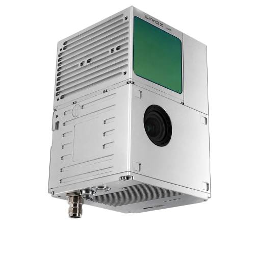
Inquiry
Overview
Key Features
Parameters
Applications
Download
Related Products
Overview
The SC100 3D laser scanning system is a drone platform measurement system developed by Kilichain. It is highly integrated with laser scanners, GNSS, INS inertial navigation systems and cameras. It is able to quickly obtain high-precision laser point clouds and is being widely used in digital city construction, manufacturing, land surveying and mapping, forestry, precision agriculture and other fields. The system's fast and efficient acquisition of point data has brought unprecedented measurement experience to various industries.
Key Features
Multi-platforms
The equipment is suitable for use on multiple platforms. It supports airborne (such as vertical fixed-wing, multi-rotor and helicopter.), vehicle-mounted, shipborne, handheld and other mobile platforms to meet the different operating environments of customers' various projects, reduce equipment procurement costs, and improve the efficiency of customer companies.
Highly Integrated
It is designed to be highly integrated with laser scanner, GNSS satellite positioning system, INS inertial navigation system and camera, and can quickly obtain high-precision laser point cloud.
Easy to Operate
Our products are designed to be simple to operate and eliminate complex settings, so that even novice users of laser LiDAR products can master the use and understanding of radar in a short time with a small amount of training.
High Precision
The LiDAR equipment can be compatible with RTK and PPK solution modes when needed, providing high-precision data information to meet the high demand for accuracy in multiple fields.
Specification Excerpts
Performances
Laser Unit
Measuring range190m@10%
Laser class905nm Class1
Laser line number64-beam
FOV70°the cirular view
Range Accuracy (1σ @ 20m)2cm
DataTriple echo,720,000 points/Sec
POS Unit
Update frequency200Hz
Pitch / Roll accuracy0.015°
Heading accuracy0.040°
Positioning accuracy≤0.05m
GNSS 

GPS: L1/L2/L5

GLONASS: L1/L2

BDS: B1/B2/B3,

Galileo: E1/E5a/E5b

Camera
FOV83°
Resolution26 mp
Focal length16mm


Physicals
Size155x92x93mm
Weight1020g
ColorSilver
Working temperature
-20° to +55°
Storage temperature-20° to +55°


Electricals
Applications
Mine Management
Download
欢迎:
Related Products