

Jiaxing, May 19, 2026
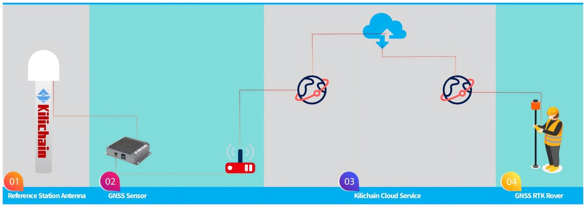
Kilichain GNSS, leveraging years of experience in the GNSS (Global Navigation Satellite System) field, is committed to providing users with a truly "out-of-the-box" CORS (Continuously Operating Reference Station) service. We understand the pain points of traditional CORS services, such as complex software parameters, cumbersome communication protocols, and high server configuration barriers. Therefore, we have highly simplified and intelligently encapsulated the entire system. Customers no longer need to worry about cumbersome software configurations, nor do they need to spend time on technical details such as data link matching, port forwarding, and mount point settings between base stations and rover stations. After completing the physical setup and installation of the hardware, users only need to follow our standardized operating documentation to perform a one-time coordinate input and basic settings for the base station to quickly enable CORS RTK (Real-Time Dynamic Differential) working mode. The entire process is clear and straightforward; even surveyors new to CORS systems can independently complete the deployment in a short time, significantly lowering the barrier to entry for high-precision positioning technology.
Within network coverage areas, users only need to log in to Kilichain's server via mobile network or dedicated data link to immediately enter RTK high-precision measurement operation mode. The system automatically handles differential data transmission, coordinate calculation, and accuracy control between the base station and the rover, eliminating the need for users to frequently switch configurations or repeatedly verify the communication link. Whether in open urban surveying, road and bridge construction, or in obstructed environments such as forest edges and farmland irrigation projects, Kilichain CORS maintains stable RTK calculation performance, providing reliable, high-precision positioning results. We specifically remind users to select an appropriate working distance (i.e., the baseline length between the rover and the base station) based on their measurement or engineering accuracy requirements in actual projects. Different working distances correspond to different differential errors and positioning convergence capabilities; properly controlling the baseline length is a crucial prerequisite for ensuring the final coordinate accuracy meets project design specifications.
Kilichain CORS is designed with the core philosophy of "reducing user burden and improving operational efficiency," transforming complex CORS technology capabilities into a simple, transparent, and predictable standardized process. We not only provide comprehensive server access services but also prioritize the quality of user results and data reliability in actual projects. By streamlining configuration steps, optimizing operation documentation, and strengthening network compatibility testing, we ensure that users receive clear guidance and timely feedback throughout the entire process, from powering on the device to conducting measurements. Whether it's routine small-scale terrain surveying or large-area engineering mapping using multiple base stations, Kilichain CORS helps users successfully deploy and operate in CORS RTK mode with less preparation time and less reliance on specialized knowledge. Choosing Kilichain GNSS means you'll have a professional and user-friendly high-precision positioning partner, allowing surveying to return to its essence—fast, accurate, and worry-free.
This is a standard single-base station CORS package checklist, which can be installed after the customer finds an installation site.
Checklist:
1. GNSS Sensor CS80
2. CORS station antenna KAN150 or KAN2029
3. Accessories (support, cables, screws, feeder, etc.)
The installation steps are not complicated:
1. Select an outdoor location where the antenna can receive satellite signals effectively.
2. Construct the support pilar.
3. Measure the height and center coordinates of the support pole.
4. Install the antenna.
5. Connect the GNSS Sensor and connect it to the network.
6. Set the base station coordinates.
7. Use the rover to log in to the server and perform RTK operations.
About Kilichain
Kilichain is a fast-growing provider of end products, creative designs, solutions and technologies for geospatial, construction, navigation and timing applications. Our product portfolio includes GNSS precision measurement, automatic navigation, precise timing, and unmanned & automated system solutions based on our products and technologies. We help customers meet and overcome challenges in a more convenient way, providing our customers with more competitive technical solutions.