What is The PPP?
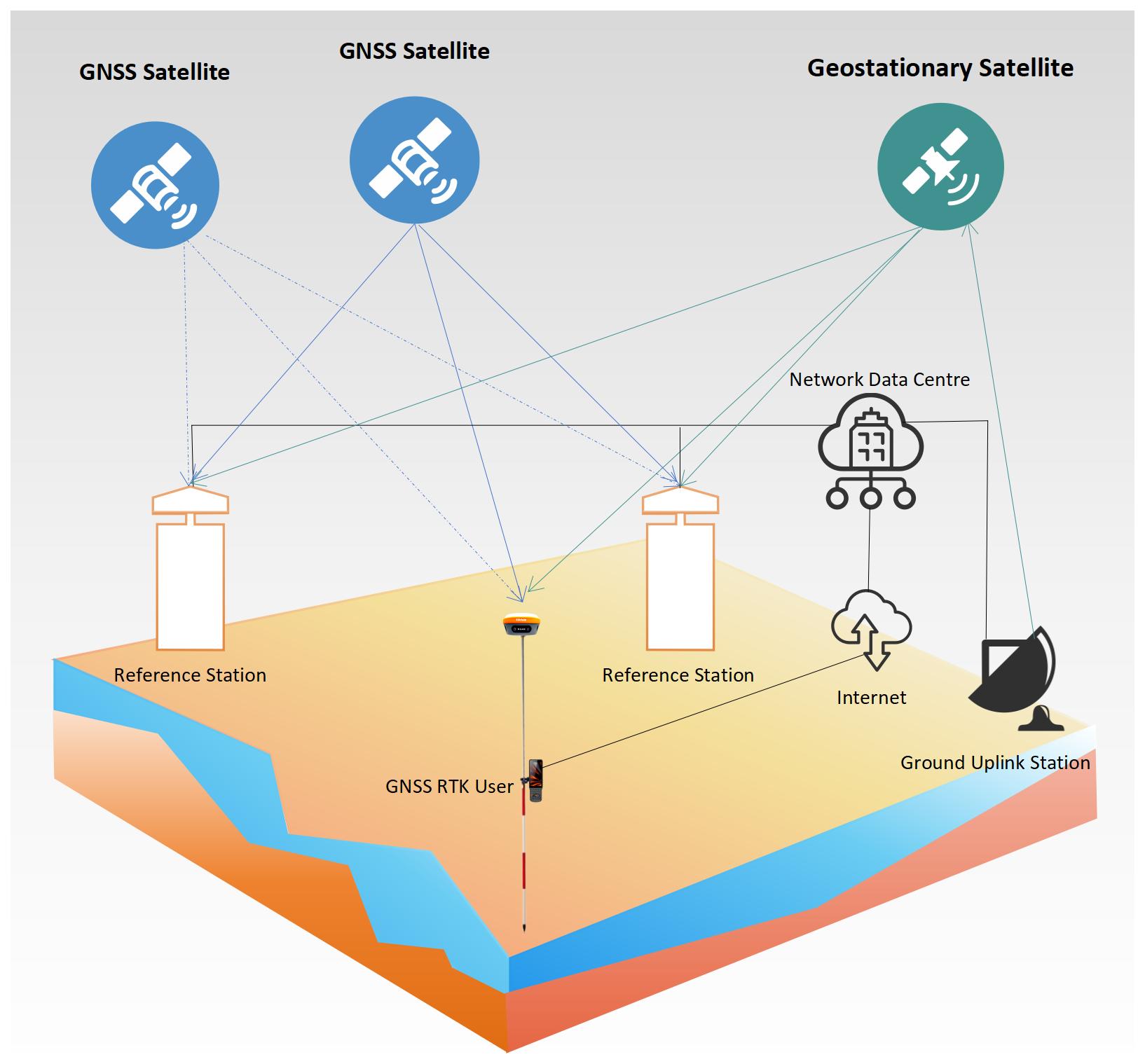
PPP (Precise Point Positioning) is a positioning technology that provides a high level of positioning accuracy with a single receiver by eliminating or simulating GNSS errors. PPP solutions rely on a set of correction values generated by a global reference station network. Once the correction values are calculated, they are sent to the end user via satellite or the Internet. The receiver uses these correction values to improve positioning accuracy.
A typical PPP solution takes some time to converge to full accuracy to account for any local errors such as atmospheric errors, multipath, and receiver bias. The actual accuracy achieved and the required convergence time depend on the quality of the correction values and how they are applied in the receiver. With advanced correction values and receiver technology, up to centimeter-level positioning accuracy can be achieved within one minute.
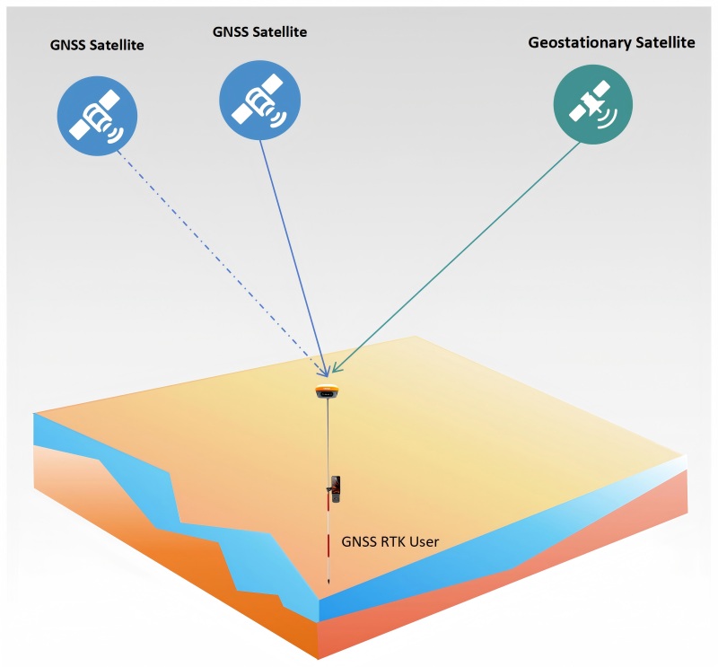
PPP positioning technology is currently widely used in land surveying, robotics, automatic navigation, agriculture, infrastructure engineering, mining and other fields that usually require centimeter-level accuracy.

In the past, traditional single-point positioning used pseudo-range observations (C/A code or P code) for positioning, which could only achieve meter-level or even worse accuracy and could not meet the scene requirements of high-precision positioning. Precise Point Positioning technology uses precise satellite orbits and precise satellite clock corrections, as well as non-differential carrier phase observation data of a single receiver for single-point positioning to achieve centimeter-level positioning accuracy.
Compared with RTK technology, which is also centimeter-level high-precision positioning, PPP has two major advantages: first, a single receiver supporting PPP function can achieve centimeter-level positioning, without considering the base station installation or CORS coverage; second, it can maintain globally consistent positioning accuracy.
In theory, PPP accuracy can reach centimeter level, but it takes a period of convergence to achieve this accuracy. In actual use, PPP positioning accuracy is related to the following factors:
1. Convergence time
2. Correction data quality
3. The surrounding environment of the positioning receiver, such as whether there is occlusion and multipath effect
4. PPP filtering algorithm
The error sources that affect PPP can be mitigated by modeling, estimating and applying external corrections.
Modeling
Some phenomena are predictable and can be modeled by mature scientific models. Phenomena that can be well modeled include solid tides, antenna phase winding, and the dry part of tropospheric delay. The wet part of the tropospheric delay (e.g. local humidity level) can also be modeled, but since it varies greatly, modeling errors must also be estimated.
Estimation
The unknown components in the system are estimated using conventional estimation strategies. In addition to estimating the receiver position, many parameters must be estimated. These parameters include ionospheric delay, tropospheric residual delay, receiver biases, and carrier phase ambiguities.
Applying external corrections
The PPP correction provider provides correction data to account for satellite clocks, orbits, and biases. In some regions, atmospheric correction data can also be provided in the correction data stream. Correction data is usually provided via satellite or internet connection.
The PPP service provider operates a network of ground reference stations that collect correction data for the different signals transmitted by each satellite. Correction data calculated from these data are transmitted from the geostationary satellite to the PPP end-user's receiver.
How to Use GNSS RTK Technology to Obtain High-precision Coordinates?
To obtain high-precision coordinates using GNSS RTK (Real-Time Kinematic) technology, follow these steps:
1. Set Up the Base Station
- Location:
- Choose a location with a known, stable point that has precise coordinates (e.g., a surveyed benchmark or a point with well-documented coordinates).
- Ensure the location is free from obstructions like tall buildings, trees, or other obstacles that could block the GNSS signals.
- GNSS Receiver:
- Power on the GNSS receiver capable of RTK.
- Ensure the receiver is securely mounted on a tripod or stable platform.
- Verify that the receiver has a clear view of the sky to receive signals from multiple satellites.
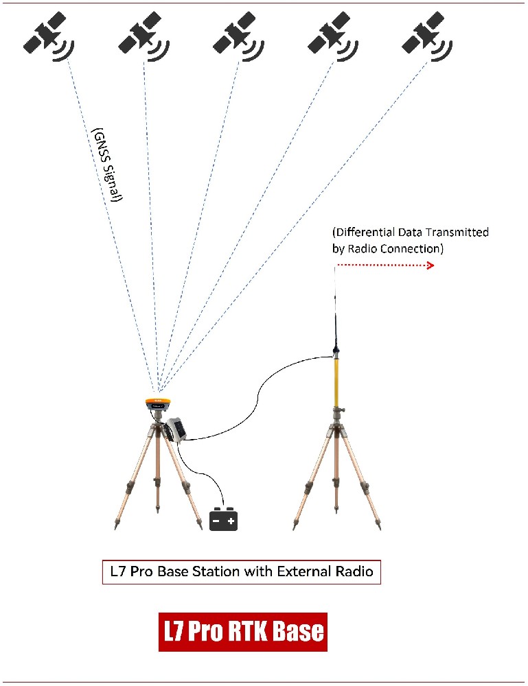
- Configure the base station to transmit correction data to the rover (usually via radio, cellular, or internet).
2. Set Up the Rover
- GNSS Receiver:
- Use a high-quality GNSS receiver with RTK capability.
- Ensure the rover receiver is also mounted securely and has a clear view of the sky.
- Power on the rover and establish a connection with the base station to receive real-time correction data.
- Verify that the rover is receiving correction data from the base station and that the RTK solution is fixed (indicating high-precision positioning).

Additional Considerations:
- Communication: Ensure reliable communication between the base station and rover (e.g., radio link, cellular network, or internet).
- Coordinate System: Confirm that both the base station and rover are using the same coordinate system and datum.
- Environmental Factors: Be aware of environmental factors like multipath interference (reflections of GNSS signals) and ionospheric disturbances, which can affect accuracy.
- Calibration: Perform any necessary calibration or initialization procedures as required by your equipment.
3. Establish Communication
- Data-Link: Set up a communication link (radio, cellular, or internet) between the base station and rover one.
- Corrections: The base station sends real-time correction data to the rover.
4. Initialize RTK
- Fix Ambiguities: The rover must resolve integer ambiguities in carrier-phase measurements.
- Initialization Time: This can take a few seconds to minutes, depending on satellite visibility and signal quality.
5. Collect Data
- Positioning: Once initialized, the rover provides real-time, centimeter-level accuracy.
- Logging: Record the coordinates as needed.
6. Verify Accuracy
- Checkpoints: Compare rover coordinates with known control points to ensure accuracy.
- Quality Control: Monitor the RTK solution's quality indicators, such as fix status and PDOP (Position Dilution of Precision).
7. Post-Processing (Optional)
- Data Logs: If higher precision is needed, log raw data from both the base and rover for post-processing.
- Software: Use specialized software to refine the coordinates further.
Key Considerations:
- Satellite Visibility: Ensure both base and rover have a clear view of multiple satellites.
- Signal Quality: Avoid obstructions and multi-path effects.
- Base-Rover Distance: Keep the distance within the effective range of the communication link and RTK performance (typically up to 10-25 km).
By following these steps, you can achieve high-precision coordinates using GNSS RTK technology.
What is The CORS?
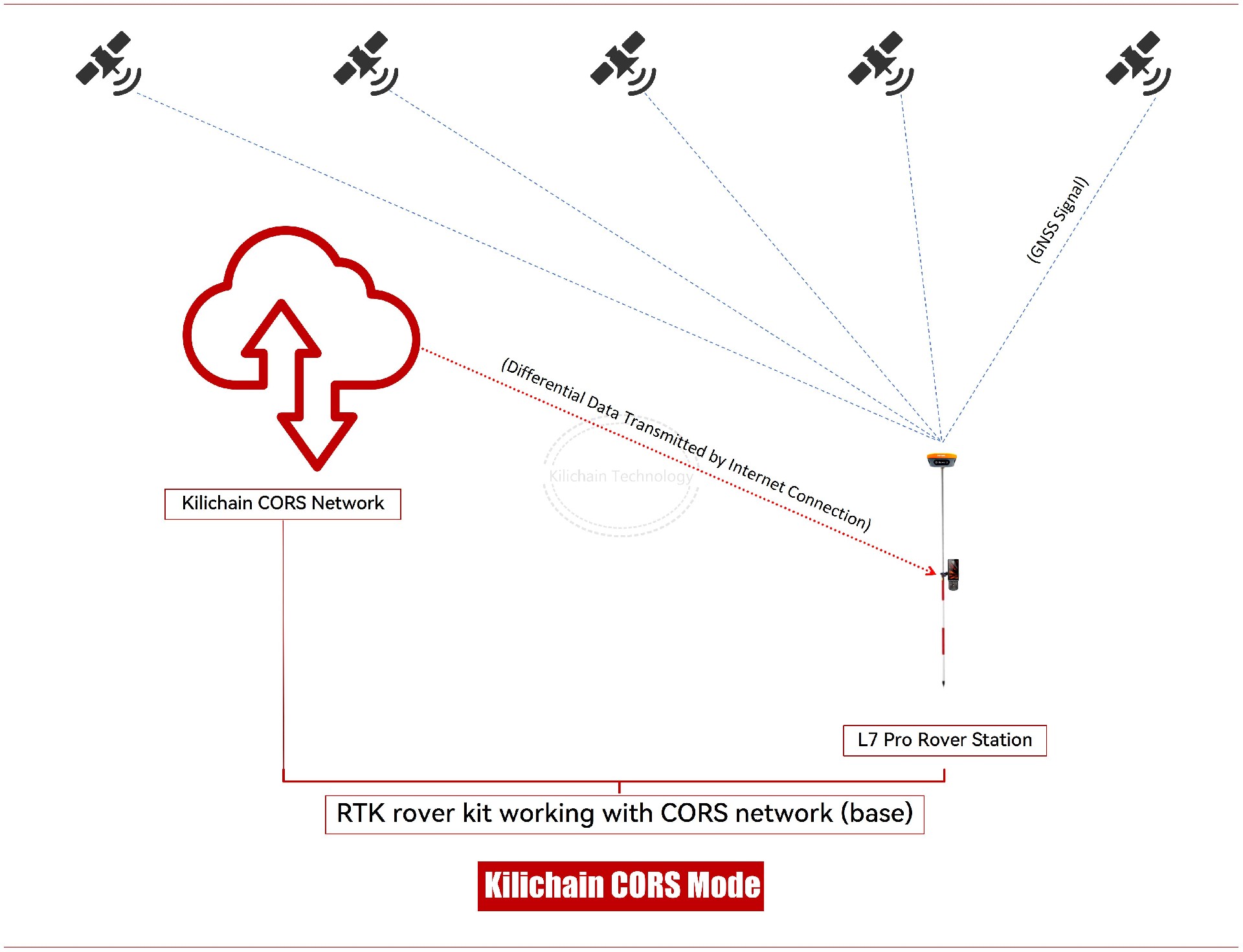
CORS, which stands for Continuously Operating Reference Stations, is a technology widely used in the field of surveying and mapping. It is a network of permanent GPS stations that provide real-time, high-precision positioning data to users.
Here's a breakdown of CORS technology:
1. Network of Reference Stations:
CORS consists of a network of permanently installed GPS receivers at known locations.
These stations continuously collect satellite data 24/7.
2. Data Collection and Processing:
The reference stations collect raw GPS data, including carrier phase and code measurements.
This data is then transmitted to a central processing facility.
3. Real-Time Corrections:
The central processing facility uses sophisticated algorithms to analyze the data from all the reference stations.
It calculates errors and biases in the GPS signals caused by factors like atmospheric disturbances and satellite orbit errors.
These corrections are then transmitted to users in real-time.
4. Benefits for Surveying and Mapping:
High Precision: CORS provides centimeter-level accuracy, which is crucial for applications like land surveying, construction, and precision agriculture.
Real-Time Positioning: Users can receive real-time positioning data, eliminating the need for post-processing and saving time.
Increased Efficiency: CORS allows surveyors to work faster and more efficiently, as they don't need to set up their own base stations.
Cost-Effectiveness: By utilizing a shared network of reference stations, CORS reduces the need for individual users to invest in expensive equipment.
5. Applications of CORS:
Land Surveying: CORS is used for boundary surveys, topographic mapping, and construction layout.
Precision Agriculture: Farmers use CORS for guidance systems, yield monitoring, and variable rate applications.
Geodetic Monitoring: CORS is used to monitor tectonic plate movements, subsidence, and other geophysical phenomena.
Autonomous Vehicles: CORS provides high-precision positioning data for autonomous vehicles like drones and self-driving cars.
In conclusion, CORS technology has revolutionized the field of surveying and mapping by providing real-time, high-precision positioning data. Its applications are vast and continue to expand as technology advances.
GNSS RTK Technology in Surveying Engineering
GNSS RTK Technology in Surveying Engineering
Introduction
Global Navigation Satellite Systems (GNSS) have revolutionized the field of surveying by providing highly accurate positioning data. Among the various GNSS techniques, Real-Time Kinematic (RTK) positioning stands out as a powerful tool for achieving centimeter-level accuracy in real-time. This article explores the principles, components, and applications of GNSS RTK technology in surveying engineering.
Principles of GNSS RTK
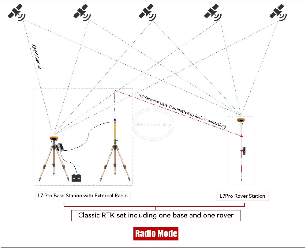
GNSS RTK is a satellite-based positioning technique that enhances the accuracy of GNSS measurements. Traditional GNSS systems, such as GPS, provide positioning accuracy within a few meters. However, RTK improves this accuracy to within centimeters by using a combination of a fixed base station and a mobile rover.
The base station, positioned at a known location, receives signals from GNSS satellites and calculates its position. Since the base station's location is known, it can determine the errors in the satellite signals. These errors, known as corrections, are then transmitted to the rover in real-time via a radio link or cellular network. The rover applies these corrections to its own GNSS measurements, significantly improving its positional accuracy.
Components of GNSS RTK Systems
1. Base Station: A stationary GNSS receiver placed at a known location. It continuously tracks satellite signals and computes corrections.
2. Rover: A mobile GNSS receiver that moves around the survey area. It receives corrections from the base station and uses them to determine its precise position.
3. Communication Link: A means of transmitting correction data from the base station to the rover. This can be achieved through radio signals, cellular networks, or internet-based protocols.
4. GNSS Satellites: The constellation of satellites that provide the signals used by both the base station and the rover to determine their positions.
Applications of GNSS RTK in Surveying Engineering
1. Land Surveying: GNSS RTK is widely used for cadastral surveys, topographic mapping, and construction layout. Its high accuracy and real-time capabilities make it ideal for establishing property boundaries, creating detailed maps, and setting out construction sites.
2. Precision Agriculture: Farmers use GNSS RTK for precise planting, fertilizing, and harvesting. The technology enables automated machinery to follow predefined paths with centimeter accuracy, optimizing crop yields and reducing input costs.
3. Construction: In construction projects, GNSS RTK is used for site preparation, grading, and machine control. It ensures that earthmoving equipment operates with high precision, reducing material waste and improving project efficiency.
4. Geodetic Surveys: GNSS RTK is employed in geodetic surveys to establish control points with high positional accuracy. These control points serve as references for other surveying activities and spatial data collection.
5. Environmental Monitoring: GNSS RTK is used to monitor environmental changes, such as land subsidence, glacier movement, and coastal erosion. Its high accuracy allows for the detection of subtle changes over time.
Advantages of GNSS RTK
- High Accuracy: GNSS RTK provides centimeter-level accuracy, which is essential for many surveying applications.
- Real-Time Results: Surveyors can obtain precise positioning data in real-time, improving efficiency and reducing the need for post-processing.
- Versatility: GNSS RTK can be used in various environments, including urban areas, rural landscapes, and remote regions.
- Cost-Effectiveness: By reducing the time and labor required for surveying tasks, GNSS RTK can lower overall project costs.
Challenges and Limitations
- Signal Obstruction: GNSS RTK requires a clear line of sight to satellites. Obstructions such as buildings, trees, and terrain can affect signal reception and accuracy.
- Communication Range: The effectiveness of RTK depends on the range of the communication link between the base station and the rover. In remote areas, maintaining a reliable connection can be challenging.
Conclusion
GNSS RTK technology has become an indispensable tool in modern surveying engineering. Its ability to provide highly accurate, real-time positioning data has transformed traditional surveying practices, enabling more efficient and precise data collection. Despite some challenges, the benefits of GNSS RTK make it a valuable asset for a wide range of applications, from land surveying and construction to precision agriculture and environmental monitoring. As GNSS technology continues to evolve, the capabilities and applications of RTK are expected to expand further, driving innovation in the field of surveying engineering.

